Geotest - download latest version
Geotest version 3.60 ~ 30.12.2025
The Geotest setup is the complete installation package and contains all the program files, driver files, PFD manuals (english and german manual) and example data. After installation, the Geotest program works as a limited demo version. After additional online activation, this works as a full (unlimited) version for registered users.
Geotest complete setup: GeoTest_Setup.exe
Geotest complete setup as ZIP file: GeoTest_Setup.zip
GeoTest: English manual
GeoTest: Deutsches Handbuch
Geotest Tutorial
Geotest version 3.60 ~ 30.12.2025
- New statistics option: correlations of measured data
Geotest main menu > data > edit > correlations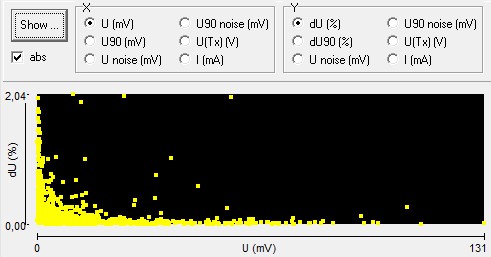
- COM handling improved: in case of connection loss automatic reconnection of USB-serial converter
- Check overload of ActEle buffer amplifier (SAT) available since 4PL firmware 5.6.0.36
- Summary at the end of a measurement improved
- Handling of data table improved: mouse wheel scrolling enabled
- Handling of data table improved: option for colored marks
 e.g. for voltage deviation above the limit
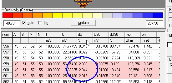
- New option for reading two MON CSV files containing header and data
- Bug repaired in reading MON data with unusual (reverse) cable settings
- Last but not least: The Geotest program author Dr. Armin Rauen has retired at 01.01.2026
Arne Schwab is the successor and he continues all araound Geotest
Arne Schwab
Schwab Research Technology (SchwaRTech)
Applied Geophysics and Development
Steuben-Allee 29
D-28832 Achim, Germany
Tel = +49 4202 7655563
eMail = aschwab@schwartech.de
iNet = www.schwartech.de